
Rail Baltica’s Geotechnical Foundation: Tootsi-Ikla Survey
Geotechnical investigations are essential for Rail Baltica, providing a thorough understanding of subsurface conditions to ensure long-term stability and safety of high-speed rail lines, minimizing environmental impact, and contributing to the project’s success.
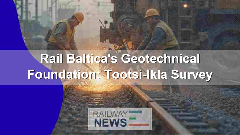
This article explores the critical geotechnical investigations underway for the Tootsi-Ikla section of the Rail Baltica project in Estonia. Rail Baltica, a large-scale railway infrastructure initiative aiming to connect the Baltic States (Estonia, Latvia, and Lithuania) with Poland and the wider European Union network, necessitates meticulous groundwork to ensure the long-term stability and safety of its high-speed rail lines. The focus here will be on the significance of geotechnical surveys in informing the design and construction phases, minimizing environmental impact, and ultimately contributing to the success of this ambitious project. We will examine the phases of geotechnical investigation, the techniques employed, the selection of contractors, and the overall implications for efficient and sustainable railway development within the context of Rail Baltica’s broader goals. The robust understanding of subsurface conditions derived from these investigations is paramount for cost-effective design and construction, avoiding unforeseen challenges and delays during subsequent stages.
Geotechnical Investigations: A Foundation for Rail Baltica
The initiation of geotechnical investigations marks a crucial phase in the Rail Baltica project’s development. These investigations are not merely preliminary; they are fundamental to establishing a robust and safe railway infrastructure. The extensive nature of the survey – covering the entire Tootsi-Ikla section – underscores the commitment to thoroughness and precision. The two-year duration of the work further emphasizes the depth and complexity of the analysis required to fully understand the soil characteristics along the designated route.
Methodology and Data Acquisition
The geotechnical investigation utilizes a phased approach. The initial phase involves drilling boreholes at approximately 300-meter intervals along the corridor. This provides a preliminary overview of the soil profiles. Subsequent phases will involve a denser network of boreholes, with drilling frequency reduced to approximately 100-meter intervals. This denser network will provide a higher-resolution picture of the subsurface conditions, enabling more precise design and construction specifications. The parameters examined include soil water levels, soil strength indicators, and the overall suitability of the soil for supporting the planned railway infrastructure. The use of tracked drilling machines minimizes environmental disruption and damage to the surrounding ecosystem, highlighting a responsible approach to construction.
Contractor Selection and Collaboration
The selection of experienced geotechnical firms – Geoprovi, Geotecnia y Sondeos, and Geostand – underscores the project’s commitment to quality and expertise. The combined experience of these companies will provide a detailed and reliable dataset upon which the engineering design can be based. The collaboration between RB Rail, the project’s joint venture (JV), and the selected contractors is vital for coordinating efforts and ensuring data consistency. The synergy between design and construction phases through this careful selection and collaboration is key to minimizing potential complications.
Design and Engineering Implications
The geotechnical data gathered will directly influence the design of the railway line. This encompasses several key areas: the foundation design for the track, the design of associated infrastructure such as embankments and culverts, and the overall structural design of the railway line. Understanding the soil’s bearing capacity is crucial for determining appropriate foundation depths and types. Similarly, knowledge of potential soil instability or other subsurface challenges enables engineers to design mitigation measures, preventing issues such as settlements and landslides that could impact the long-term stability and safety of the line. Additionally, integrating the geotechnical data early in the design phase enables optimization of the design, minimizing costs, and ultimately delivering a more sustainable and cost-effective project.
Conclusions
The geotechnical investigations underway for the Tootsi-Ikla section of Rail Baltica are a testament to the project’s commitment to building a safe, robust, and sustainable high-speed rail network. The two-year duration and phased approach of the survey, incorporating high-resolution data acquisition techniques, demonstrate a thorough and methodical approach to understanding the complexities of the subsurface conditions. The selection of highly experienced geotechnical contractors further underscores this commitment to quality and expertise. The data gathered will play a pivotal role in informing the design and construction phases, ensuring that the final design is optimized for cost-effectiveness, stability, and minimal environmental impact. This meticulous groundwork is not simply a prerequisite; it is an investment in the long-term success of Rail Baltica and its integration into the broader European rail network. By carefully considering the geological properties, the project can avoid costly errors and delays down the line, leading to a more efficient and sustainable project delivery. This detailed approach establishes a benchmark for future railway infrastructure projects, ensuring the highest standards of safety and longevity. The success of Rail Baltica hinges on the meticulous planning and execution of such foundational steps, proving that a strong beginning lays the groundwork for a successful railway system. The integration of such thorough geotechnical studies sets a new standard for responsible and effective railway infrastructure development globally. The meticulous planning and execution of these initial phases ensure that the Rail Baltica project continues to set a new benchmark for sustainable and effective high-speed rail infrastructure development worldwide.
Railway infrastructure, rolling stock and transport technologies specialist focused on global rail industry developments, high-speed rail systems, signaling technologies and freight transportation. Covering railway investments, public transport modernization, rail operations and international mobility projects across Europe, Asia and North America.
BENZER KONULAR
July 4, 2026 11:41 pm
Eurostar cancelled all direct London–Amsterdam trains through July 2 after...
July 1, 2026 1:37 pm
NRHS awarded $187K to 34 U.S. rail heritage projects in...
July 4, 2026 11:02 pm
Eurostar suspends all direct London–Dutch trains through 2 July after...
BART secured the non-monetary GFOA Triple Crown Award for fiscal...
July 7, 2026 12:01 am
Hitachi Rail completed the acquisition of Clever Devices, a U.S....
July 1, 2026 4:22 pm
Správa železnic opened a €60M multimodal hub at Jihlava město...